Annotations
For map plots in particular, it can be useful to have text annotations next to each data point.
verif raw.nc -m mae -type map -latrange 59,61 -lonrange 5,8 -maptype simple -a
This labels each data point with the location id and its verification score. This is a quick way to find location ids and then do a separate verification for that point.
(From v1.3.0) To set what fields are shown in the map annotations, use -af followed by a comma-separated
list of fields. Supported fields are value,lat,lon,elev. To only show the verification score and the station
elevation, use this:
verif raw.nc -m mae -type map -latrange 59,61 -lonrange 5,8 -maptype simple -a -af value,elev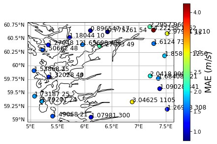
For figures other than maps, the x and y coordinates are annotated:
verif ECMWF.nc MEPS.nc -m mae -a
The font size of the annotations can be set using -afs.